Tour 1 Section A - Conneaut to Cleveland
Conneaut
The unrelenting July heat in Columbus inspired me to look for the coolest part of the state I could find. Though the world-wide-intertubes said it was still in the mid-90s along the shores of Lake Erie, a steady breeze and the sight of water would be an oasis compared to the oppressive 106° of Franklin County. I decided to take U.S. 20 across northern Ohio, which also happens to be Tour 1 in TOG.
The route that became U.S. 20 has been in use for many hundreds of years. During the 17th century, the then-five nations of the Iroquois pushed the Erie, Huron, and other Algonquian peoples west along this route in order to take control of the bountiful beaver population in the region (and augment their population through a process known as Mourning War, but that is a whole other story). Later, this road became the chief avenue for Euro-American settlement of the Western Reserve. At the time of TOG’s publication in 1940, it was one of the primary east-west thoroughfares in the country: a road where “busy lake ports, prim villages with a New England air …and a number of industrial centers” stand side-by-side with “parks, vineyards, orchards, and the largest nurseries in the State.” Though the ports are not as busy, much of the description still holds true. Such is the case with the port city of Conneaut whose industrial waterfront bisects the Conneaut Wilderness Area.
When Moses Cleveland, the surveyor for the Connecticut Land Company, briefly stopped at the mouth of what became Conneaut Creek in 1796, he established the town of Salem. Sometime in the 1830s, the name was changed to Conneaut (ko’- ne – ot) which TOG states is “an Indian word variously interpreted to mean ‘fish’ or ‘snow place,’ or it may be a corruption of gunniate, which means ‘it is a long time since they have gone.'” According to the American Bureau of Ethnography, that “Indian word” is probably of Iroquois origins (a safe bet considering the region’s history), but the vagueness of its meaning and the date of its inception hints at a different etymology.
As historians such as Phillip Deloria have explained, Americans and even proto-Americans have a long history of appropriating aspects of Indian identities as way to distinguish themselves from Europeans. While Europeans have Greek and Roman antiquities, the argument goes, Americans have Indians (It is not a coincidence that the Boston Tea Party, the most storied act of civil disobedience in American history, was perpetrated by a group of “Mohawks” whose demands needed to be “translated” into english). This affection for an Indian past has been most obvious during periods of cultural anxiety as Americans have looked for “authenticity” in a rapidly changing world (Again, it is no coincidence that the Wild West shows reached their peak during a period of massive industrialization and urbanization at the turn of the nineteenth century, or that the creation of the famous “Crying Indian”—who sheds a tear as “white” people throw litter out of their cars— coincided with the post-industrial anxiety of the 1970s).
The 1830s typified one of these periods of anxiety. This sentiment is best seen in the Romantic writers and painters whose works spoke to society’s unease with the huge cultural and social shifts brought about by projects like the textile mills in Lowell, MA, and the Erie Canal. The last painting in Thomas Cole’s seminal five-piece series, “The Course of Empire” (1834-1836), for example, dramatically illustrates the consequences of over-industrialization and the price of its trappings.

Desolation, 1836, Thomas Cole / Wikipedia Commons
For many towns, the anxiety surrounding industrialization manifested itself through the creation of an idealized Indian history. Sometimes this took the form of a recently discovered tree or rock or grove where “Indian councils” took place. Other times, as perhaps was the case of Conneaut, an Indian name was adopted, thereby proving its Native bona fides. Conneaut may in fact be an Iroquoian word, or it may simply be what an 1830s resident of the town believed an Iroquoian word sounded like.
Regardless of its name, Conneaut grew rapidly at the end of the nineteenth century as a transportation hub for the iron and coal found in the region. Along with its natural harbor, one of the largest iron ore receiving ports in the world in 1940, it was dividing point for the New York, Chicago & St. Louis Railroad Company, commonly called the Nickel Plate Railroad. Perhaps because of the land needed for the railroad yard, the town grew up a few miles inland, rather than on the shore. Standing in the center of the business district today, there is little indication that this was once part of a major transportation hub.
Conneaut has a historical society which is housed in an old freight depot, as well as a railroad specific museum that contains one of the last Nickel Plate cars. Considering this history, I expected to find a number of sites in TOG related to either the railroad or the port. In fact, there is only one point-of-interest (POI) for Conneaut in TOG (a house built in 1800 which no longer stands) and only one more in the manuscript version, neither of which has any connection with trains or shipping. I soon found this to be a common theme for Tour 1. Unlike Tour 8 which focuses on industry and public spaces, this tour highlights architecture and private homes: a characteristic that underscored the subjectivity of both TOG and my re-creation of it.
This subjectivity was apparent as soon as I got out of the car in Conneaut. Directly across the street from where I parked was a boulder with a metal plaque, erected in 1937, indicating that this was the site of an old school. Particularly in towns without a lot of POI, TOG generally highlights this sort of memorial. Since the manuscript only lists one other POI and the writer most likely passed through Conneaut within a few months of the monument’s creation, it seems like an obvious choice to be included. As it was, however, I simply stumbled across it.

Site of Old Academy, 2012
Yet, the exclusion of this monument is no stranger than the inclusion of the only POI the author of the manuscript did include:
Left on Center Road is Fort Conneaut or as it is sometimes called, “Fort Hill”. This mountainous hill, with many trees growing upon it… was once an Indian fortress. …A steep ascent protects it on all sides with the only approach being up a gradual slope…left by the wash of the river. The only indication of constructed defenses, a simple earth wall built on the very edge of the bluff, is found on the summit….The area thus enclosed, a triangle of about 2 acres is perfectly level.
With the exception of the name “Center Road” being changed to “Mill Road,” the description in the manuscript still applies to the triangle of land taken up by the City Cemetery of Conneaut. There is even still a path, snaking up the narrow strip of land left by the wash, though most visitors reach the cemetery by the road on the north side or a set of steep stairs carved into the eastern slope. Considering its purported historical significance, it struck me as odd that Fort Conneaut did not make it into the printed TOG.

"Fort Conneaut", 2012 / Google Maps

Tree-Trunk Pulpit, 2012
As I walked through the maze of headstones, I realized that this was not a particularly new cemetery. There were plenty of gravesites from the nineteenth century and even a mausoleum built into the side of the hill from 1882. Why hadn’t the author mentioned this? (My favorite gravesite, pictured above, was a collection of gravestones built around 1920 meant to look like a tree-trunk pulpit for the patriarch with corresponding logs for his wife and children). Further, while it is true that Fort Hill is the site of a former Hopewell compound perfectly situated for defense on a small elevated plane, it lies a few hundred miles to the southwest, not along Lake Erie. This seemed like a strange conflation. Perhaps, as with the renaming of Salem, the former residents of Conneaut (or the author of the manuscript) wanted to highlight an Indian past that may or may not have existed the way they envisioned.
After a web search for “Fort Conneaut” on my iPhone brought back nothing of substance, and no one in the historical society, nor anyone I asked, had ever hear of Fort Conneaut, I was ready to chalk it up to faulty research on the part of the writer. Then at one of the historical museums in Ashtabula, my next stop, I met a woman in (probably in her late 70s) who did remember being taught about Fort Conneaut as a child. “I don’t remember anything about it except that it had to do with Indians,” she said. Some work in the archives could probably put this question to bed but until then, I will not know whether I have re-found a historic Hopewell site that has been forgotten, or simply uncovered an origin tale of dubious historical accuracy.
(Update: I found the following passage in an 1878 “History of Ashtabula County,” from which the manuscript author took his information, frequently verbatim:
“Ashtabula County abounds in earthworks….That at Conneaut is situated on the summit of a lofty hill, not far from the spot where the village now stands, and almost directly across the creek from the village cemetery. It is on an isolated spot, on a hill which has been left by some former change of the bed of the stream, and which now stands an abrupt eminence, its sides washed by the waters of the stream, which flows in silence underneath its very banks. …The spot is a romantic one, and, situated almost within the sound of the roar of the surf of the lake, and in the midst of the deep valley of a swift-flowing stream, must have been a favorite resort to the ancient inhabitants. The only mark of artificial defense is found on the summit. This consists of a simple earth-wall built on the very edge of the bluff, and following closely the very line of the bluff. A ditch was on the inside of the wall, and the height of the wall may have been at one time five feet. Possibly a stockade may have surmounted it, making the inclosure doubly secure both from the natural and artificial defense… The work might have served for a defense to the various tribes of Indians which inhabited the region, or it may have been the residence of the ancient people called the mound-builders.”
The sentence describing the location of the “lofty hill… directly across the creek from the village cemetery” explains why the author of the manuscript guide did not mention the existence of the graveyard in his description of the hill: it was actually across the river on a mirror (if inverted) triangle of land. A different passage also explains the author’s misuse of the name “Fort Hill.” The author of the “History of Ashtabula,” had simply compared Fort Conneut to other Hopewell mounds “such as the kind at Fort Hill.” The manuscript author copied the sentence incorrectly.
Though this book clarifies some of the manuscript author’s mistakes, it still leaves open the possibility that this location was not used by mound-builders or “various Indian tribes” at all, but, as the bolded part of the text alludes to, was part of an origin story which grew out of the Romantic ideals of a pastoral past. There is little evidence of Indian presence, only assertions and assumptions. In fact, as I mentioned above, at the time of the “History of Ashtabula’s” printing in the last quarter of the nineteenth century, popular American culture was rife with histories of the “vanishing” Indian.
The region around Conneut was certainly home to many Algonquian and Iroquioan groups and Hopewell peoples before them. The specifics of that history, however, was (and remains) as much about a historian’s present as it was about her subject’s past).
Since there were no other POI, I wandered around a nearly-deserted Main Street for a few moments (where I took the photo below) before I joined the crowds escaping the heat in Conneaut Township Park (I certainly didn’t have the building in mind when I took the beach scene, but the lines and colors are remarkably similar, particularly if you flip the beach on its head).

Building in downtown Conneaut, 2012

Conneaut Township Park, 2012
Ashtabula
Southwest of Conneaut, U.S. 20 turns into a four-lane highway, alternating between 50 and 35 mph speed limits. Situated half-way between the more tourist-centered Lake Road to the north and Interstate 90 to the south, U.S. 20 is one of those routes where long-haul truckers exist uneasily with long-time residents making their daily pilgrimage to the post-office; traffic seems to lumber along far too slowly until you see someone try to pull out of their driveway.
After passing through the tiny hamlets of Amboy and North Kingsville (which the manuscript guide states was the site of the “first centralized school system in the United States” after the town got legislative approval to combine regional schools during an economic crisis in 1894), U.S. 20 runs into the north end of Main Avenue in the city of Ashtabula. This point marks the apex of a sort a sort of sideways isosceles triangle made up of Main Avenue running to the southwest, Lake Avenue running to the northwest, and West Avenue running north and south. These streets mark the approximate limits of what was the primary commercial, residential, and civic district of the original town which, in 1830, numbered around two thousand residents of “chiefly New England Stock.”
According to TOG, however, “the New England character of the town was modified by immigrants from Finland and Sweden who settled around the harbor in large numbers and observed their own customs.” The harbor, about a mile north of the old town center, became the commercial and cultural heart of Ashtabula. TOG describes “fishing boats tied up at the docks or drifting in and out of port; odd taverns patronized by fisherman, dock hands and sailors; gangling steel cranes deftly scooping ore from the holds of leviathan freighters into waiting railroad carriers.” An historic marker at the foot of Bridge Street expands the list of immigrants’ nationalities cited by TOG to include Irish and Italian but more interestingly, declares that these stevedores and deck hands made Ashtabula “one of the toughest ports in the world, sharing that distinction with Shanghai and Calcutta.”
With the exception of the fighting, the Ashtabula Harbor Commercial Historic District is probably not that different than it was in 1940. A mix of industry, retail, professional services, and residential buildings make up the four-block harbor district. Though it has certainly seen better days, the rough edges gives the district the feel of a working harbor. Here, boutique coffee shops look out on a railroad yard and workers from the industrial port share drinks with tourist fisherman at the Bum Boat Pub (Bum boats ferried goods to ships moored off-shore).


On the right side of the second and last photos above is the Bascule Lift Bridge. It connects the east and west sides of the harbor. The Ashtabula river was first spanned by a pontoon or floating bridge in 1850 which was replaced by a swinging bridge in 1889. In 1925, Wendell Brown designed a new bridge using the same systems of counterweights and pulleys which Thomas Brown (no relation) had used in his construction of the elevator in the Eiffel Tower decades earlier. This “bascule” bridge (a medieval term for draw bridge) is the only one of its kind still used for automobile traffic in the state and was put on the National Register of Historic Places in 1975.
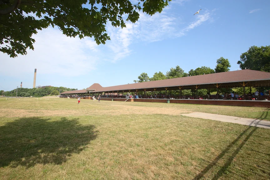
Just west of the harbor is Lake Shore Park. As the manuscript guide informs us, from here one can see the Ashtabula Lighthouse located on the breakwater offshore. Originally built in 1836, its most recent incarnation was the last manned lighthouse on Lake Erie, becoming automated in 1975. Also in the park is what a historic marker beside it says is the “longest and oldest lakefront pavilion in continuous use on the Great Lakes.” Whether due to the author’s disinterest in public spaces or its relatively recent construction (only two decades before TOG was printed) the Lake Shore Park Pavilion is not included in either the manuscript guide or TOG. This is particularly noteworthy because unlike the authors of other tours who highlighted New Deal projects, this author described neither the pavilion nor the “extensive Civilian Conservation Corps improvements” made in the area surrounding the structure which is highlighted by the historical marker.


Like many towns in the region, Ashtabula was once a center for produce and flower production. According to TOG, over 70 acres of Ashtubula was “under glass” as the hothouses produced over seven million pounds of fruits and vegetables. One of the largest of these, and one of two points-of-interest for the city, was the R.W. Griswold Company. With 500,000 square feet of mushroom beds in 1940, it was one of the largest in the country. Today, 529 Woodman Avenue is the site of a low-income apartment complex.
Underground Railroad
As TOG’s reprinting of a December 21, 1850 editorial in the Ashtabula Sentineldemonstrates, Ashtabula was once a hotbed of abolitionist activity.
Congress made a law in reference to fugitive slaves; a law to strip us of our humanity…and herd us with bloodhounds and the men stealers…Cursed be the Law!
Resolved, That we will not aid in catching the fugitive but will feed and protect him…and that we pledge our sympathy and property for the relief of any persons in our midst who may suffer any penalties for an honorable opposition or failure to comply
As an example of the city’s dedication to the cause, TOG lists the Hubbard Homestead as the second and last point-of-interest in Ashtabula. A “community house” in 1940, TOG declares it “the best known of Ashtabula’s Underground Railway stations.” According to a 1999 historic marker outside of what is now the Hubbard House Museum, William and Catherine Hubbard would shelter escaped slaves in their home before bringing them to the Hubbard and Company warehouse on the Ashtabula River a quarter of a mile away. From here ” friendly boat captains awaited to ferry their passengers to Canada and freedom.”

Hubbard House, 2012
I was too late for the tour of the Hubbard House, but with plenty of light I decided to continue on with the abolitionism theme. Following one of TOG’s side-trips off of U.S. 20, I made my way to Jefferson. Here I found the Giddings Law office where Joshua Reed Giddings and his partner Benjamin F. Wade gained national prominence as ardent abolitionists and where Giddings wrote the Republican Party’s first national platform. The building, now a museum, is on the National Register of Historic Places. A plaque outside the tiny wood structure informed me that as a congressman, Giddings defied the Atherton Gag Rule which prohibited the discussion of slavery on the floor. He was abruptly censured by the House after which he resigned in protest. His absence was not long, however, as he was reelected five weeks later.
For his part, Wade was the acting Vice-President at the time of Andrew Johnson’s impeachment proceedings and was therefore one vote shy of becoming president of the United States. A monument marks the site of his home a few doors down from the Giddings Law office which was “well preserved” according to the manuscript. It has since been replaced with a bank (As an interesting example of how photographer’s can manipulate space, I have included two different angles of this monument).
In addition to these sites in TOG, the manuscript guide adds what it calls the “Woman’s Suffrage Tablet” to its tour of Jefferson. In front of what is still a Congregational church sits a small boulder with a plaque marking the spot of the “First Woman’s Suffrage Convention held in this church in 1844 by the Ashtabula County Women’s Anti-Slavery Society.” Women’s rights groups in the mid-nineteenth-century frequently grew out of anti-slavery organizations so it is not surprising that the words “John Brown Spoke here in 1859” were also engraved on the memorial. What is surprising is the date of the suffrage convention. If the plaque is correct, not only did this convention pre-date what is commonly referred to as the the first women’s rights convention in Ohio (Salem, 1850), but it also preceded the famous Seneca Falls, NY, convention by four years.


A few miles from Jefferson, just south of Austinburg, a marker put up by the Ohio Historical Society marks the home of Betsey Mix Coles who was the presiding officer at that 1850 Salem convention. The marker also claims that this was “Ohio’s first women’s rights convention,” seemingly contradicting the monument in Jefferson. Perhaps more “women’s rights” than just suffrage were discussed at the Salem convention, though this seems like a small distinction. The Cowles Homestead was also, according to the manuscript guide, a stop on the Underground Railroad. It remains a private residence today.

Cowles Homestead, 2012
Another stop on the Underground Railroad is what the manuscript guide calls the Old Miller Home, a few miles north in Austinburg. As I wrote at the beginning of this tour, the author of this manuscript guide was smitten with details about the contents and architecture of private homes. At the Cowles Homestead for example, he wrote of a “hand-woven carpet, about 18″x20″ which covers the parlor floor.” The fate of most of these details have been lost to history (though I must confess I didn’t ask the current owners about a hundred-year-old rug that used to be in their living room) but one description seemed to be quite visible on the Old Miller Home:
The place of concealment for the fugitive slaves was in a space partitioned off in the cornice of the attic near the low reaches of the rafters. It was an old saying that “it was easier to get a sinner out of hell than a negro out of Austinburg.”
The space mentioned corresponds with the location of the small rectangular windows on the house below, an unusual architectural feature that does not seem to have another explanation. Unfortunately, there was no historical marker to verify my assumption that this was the home in the manuscript guide.

Old Miller Home, 2012
The next point-of-interest associated with the Underground Railroad is what TOG calls the New England House. Lying a few miles west of Austinburg on what is now Ohio Route 84 (TOG identifies it only as “a county road” but in fact it was the well-worn Cleveland-Buffalo Road) sits what has variously been called the Webster House, the New England House, the Old Tavern and Unionville Tavern. The guide describes “an imposing three-story structure,” where “Negro slaves rested on their flight to Canada.” A 1964 article published by the Lake County Historical Society adds the following details:
The negroes entered a tunnel having its entrance near the Southeast corner of the crossroads. This led them to a deeper area under the tavern where they could stand upright and have communication with the innkeeper through a trap door. From the tunnel exit back of the tavern these slaves were released or taken by wagon to the Madison Dock where they boarded boats for Canada.
Publicly it was a tavern where soldiers, sailors, and “iron-mongers…rattled the 14-inch beams with their jollities.” Among the records and curious which were on display, the manuscript author found a ledger book that indicated a “man and his team could find lodgings for himself and beasts, including dumper, breakfast and fodder for the beats for $1.50.”
While it too has been added to the National Register of Historic Places, you would not guess as much by looking at it. The building, most recently known as The Old Tavern, is still an imposing structure but it no longer inspires jollities. It appears to have been maintained as a tavern and inn until relatively recently. Tables, chairs, and various knick-knacks can be seen through the dusty windows. The doors are looked tight, however, and I would guess it has been in this state for at least five years. The roof is collapsing and the exterior needs a good deal of repairs. Two ripped awnings just add to the lonely scene, making the building appear even more dilapidated than it probably is.

New England House aka Unionville Tavern, 2012

Unionville Tavern, 2012
Across the street lies what TOG claims is the first recorded burial in the Western Reserve: that of Colonel Alexander Harper. According to a plaque on the gates of the cemetery, in 1798 Colonel Harper and 25 settlers landed at the mouth of Cunnigham Creek, three miles to the north. They eventually made their way down to what became the township of Harpersfield, the first permanent Euro-American settlement in the Western Reserve. The gravestones for he and his wife in the middle of the picture below are certainly replacements for the originals, but there is no indication of when this occurred.

Col. Harper and Widow, 2012
Harpersfield
Colonel Harper’s grave may be in the township of Harpersfield but it lies in the unincorporated village of Unionville. The village of Harpersfield is actually about two miles southwest of Unionville, on the other side of Interstate 90. Here lies what the manuscript guide calls “a point of scenic interest.”
Though pastoral scenes were probably as popular in 1940 as they are today, TOG’s editors tended to highlight infrastructure advancements rather than their preservation. Bridges and roads were generally only included if they were new or had seen substantial improvements, particularly by New Deal agencies. It is therefor not surprising that one of Ashtabula County’s biggest tourist draws today was not even mentioned in TOG: covered bridges.
Ashtabula has more public covered bridges (17), than any other county in Ohio. It has festivals to celebrate the bridges and there are signs along the highway leading any interested driver to a self-guided tour. TOG does not list any of the bridges in Tour 1 but the manuscript guide did lead me to banks of the Grand River in Harpersfield where I could “command a fine view of the river valley.” Here “a dam, an old mill race and the old covered wooden bridge over which State 45 crosses the river, in a winding course to the surmounting bluffs, adds to the charm of the view.” Remnants of the dam and mill can be imagined, if not definitely discerned, while the bridge defines a scene that looks it should adorn a maple syrup jug (Below is an example of how you can take a photographic cliché and by simply adding a few filters in photoshop, turn it into a grainy, orangey-brownish cliché). Extensively rehabilitated in 1992, it is the longest covered bridge in Ohio at 228 feet and on the National Register.

Harpersville Bridge, 2012

Harpersville Bridge #2
This is not the Harpersville Bridge but a different covered bridge in Ashtabula County. It is, however, a more interesting photograph.

Ashtabula Bridge, 2012
What initially caught my eye as I pulled up to the river was not the Harpersfield bridge, but a couch. Sitting on a gravel wash about a hundred feet from shore was a brown couch, looking as if it was simply waiting for a television and coffee table to float by so it could reunite with friends who had inexplicably disappeared. When I asked a local fisherman how it was that a piece of furniture came to adorn his view, he answered with what I expect is not an unfamiliar phrase to his lips: “Goddamn kids.” Apparently, the couch was floated out to its spot on the wash when the water was quite a bit higher. Now, with record drought throughout Ohio, it remains an immovable memorial to the county’s wasted youth.

"Goddamn Kids," 2012
Hopper Mansion
The last stop before I made my way back up to Route 20 was the Hopper Mansion; interesting if only for the story TOG relays regarding its heritage.
Near the end of the nineteenth century-so the story goes-a hobo cadged a meal from George Hopper, a Standard Oil employee. Hopper mentioned to him the ticklish problem of preventing oil from permeating the wooden barrels used as containers; the hobo casually suggested a solution and resumed his journey. The stranger’s formula worked. When Hopper, a grateful man, built this mansion for himself he ordered that it always be open to ‘men of the road’.”
Under the heading “Where Tramps Are Welcome: Interesting Story Surrounds Stately Mansion in Ohio,” a 1902 newspaper article from the Reading (PA) Eagle adds a few details to the tale. “Fill them with water and then paint them,” was the tramp’s advice. “When they are dry, pour out the water, and the water in the wood will stay in and prevent the oil from soaking through and cutting the paint.” According to the article, this idea was Hopper’s means of “securing the vast fortune he possessed.” At his retirement, Hopper offered $25,000 to the tramp, should he be found. While no one came forward, “a whole army of tramps receive[d] benefit, for no matter how disreputable or seedy, a tramp [was] always given a square meal at the Hopper home.” Since the mansion sits a good three miles down a still-lightly-used road from what was the main thoroughfare, Hopper’s offer may had been more of spirit than of actual calories.
Nearby, a very large rocking chair advertised a wood-products company. I couldn’t help but think this would have been a wonderful sign for the property, considering its new purpose as a nursing home.

Hopper Mansion, 2012

Rocking Chair, 2012
Geneva
Geneva is a small city on the western edge of Ashtabula County. With about 6,500 residents, it is about twice as big as it was in 1940. 24% of this population claims German ancestry, unsurprising considering its name. Beyond having “extensive greenhouses and apiaries and a large implement factory,” Geneva’s most notable attraction, according to TOG, is the gravesite of Platt R. Spencer.
Spencer was responsible for creating Spencerian Script, the standard writing style for business transactions and correspondence before the typewriter and simpler Palmer method made it obsolete. This was not before Ford Motor Company and Coca-Cola adopted this style into their respective logos, however.
Because it contains only Spencer's font, the logo has no copyright but it is trademarked
Spencer was also instrumental in founding over fifty business institutes throughout the country. Now able to grant two and four-year degrees, Bryant & Stratton Colleges were initially business trade-schools whose notable first students included Henry Ford and John D. Rockerfeller.
Unlike many of the cemeteries I had visited, the Evergreen Cemetery did not have signs indicating the location of its most famous residents. I was about to give up on my search when the morning sun escaped from behind a cloud and struck a large monument, highlighting it against the deep shadows of an overhanging tree. In a fitting tribute, the front of the gravestone is an open book with separate pages dedicated to Platt and his wife Persis, while the back consists of his signature in Spencerian Script.

Platt Rogers and Persis Duty Spencer, 2012

Point of Beginning, 2012
Arcola
A few miles west of Geneva on U.S. 20 sits the Arcola House. Originally a tourist inn, what is now a lawyer’s office marks the site of a once-thriving town. In 1826, the Erie Furnace Company built a blast furnace in which to make pig iron from the region’s ore. By 1835, 2,000 people lived in area, many working for what was now the Arcole Furnace Company. Everyday 200 men made for the hinterland in order to provide enough wood to produce the charcoal needed to keep the furnace running seven days a week. As both the wood and the ore supplies dried up, the cost of maintaining the furnace and the dock used to ship the ore became too great. By 1850 all that was left at the corner of Dock Road and what become U.S. 20 was the Arcola House, the misspelled legacy of a short-lived industry.

Arcola House, 2012
Lake County Landscapes
Arcola is on the far eastern side of Lake County, the second of ten counties Tour 1 passes through on its way to the Indiana line. Throughout the first quarter of the nineteenth-century, Lake County’s fine ginger sands and silty loam allowed Ohioan’s to build one of the country’s most profitable nursery centers. The Storrs-Harrison Nurseries, covering over 12,000 acres, was the largest of these with forty acres devoted solely to roses. TOG states that in the fall and summer over 300,000 plants “unfurl[ed] their extravagant colors.” These plants were part of a twenty-mile stretch of Route 20 that was the “nursery belt of Ohio.” Although most of the historic nurseries are gone, the region is still an agricultural center. Nurseries and vineyards surround the highway, giving the area a distinctly rural feel.
Part of that feel also comes from the existence of the Perry Nuclear Generating Station which was built in North Perry in 1985. Eleven-hundred acres, approximately the same as the Storrs-Harrison Nursury, were set aside as an urban wildlife sanctuary in 1993. The sanctuary’s ponds and streams are home to heron, belted kingfisher, ducks and geese, as well as spotted turtles, an endangered species in Ohio. Then again, Lake County also happens to rank among the worst 10% of counties in the U.S. in terms of cancer risk and developmental and reproductive toxicants… so there’s that.
Lake Erie Bluffs Metropark is not part of the sanctuary, but its proximity to the generating station allows for wonderful wildlife viewing and is one of the few public access points on Lake Erie with an undeveloped shoreline. I happened to run across the park on its second weekend in existence so I had the view all to myself.


Painesville
A google search of the name Jonathan Goldsmith will bring up three pages of links on the actor who portrays the “Most Interesting Man in the World”–a brilliant advertising campaign about a singular adventurer who also happens to like Dos Equis beer–before it offers any information about a nineteenth-century architect of the same name. In 1940, however, this Jonathan Goldsmsith was famous enough that TOG gave him the title “the Western Reserve’s architect-builder.” Goldsmith lived in Painesville from 1811 until his death in 1847, spreading the gospel of late Federal and Greek-Revival architecture throughout the region.
Goldsmith built over thirty commercial and residential structures in Painesville and another fifteen scattered throughout the county and Cleveland. Two of his residential buildings are preserved in the Mentor Avenue Historic District. Here, the city of Painesville set aside fifty-four buildings of Federal, Greek Revival, Early Romanesque Revival, Italianeta, Second Empire, Queen Anne, and “twentieth century eclectic styles” to maintain what TOG calls “the prim elegance of its old houses.” This entire district was added to the National Register of Historic Places in 1979.
TOG does not included any of the houses in the Mentor Avenue District in its tour. Instead, it highlights the Gillette House as its example of Goldsmith’s work. Unfortunately, its “long round-arched windows…Classic-Coumned side porch…and ornamental balustrade” have been torn down and an empty lot occupies 106 E. Washington Street. The Ohio Guide Photograph Collection contains an image of a different Goldsmith house, however, and after a 2001 restoration, the Lew Morley House looks much like it did in 1940.

Lewis Morley House, @1940 / copyright OHS
Lewis Morley House, 2012
The other three POI for Painesville also still stand:
The Rider Inn, built in 1818 was patterned after George Washington’s Mount Vernon home and was once a stop on the Cleveland-Buffalo stage route.
The Painesville City Hall was originally built as the Lake County Courthouse in 1840 before it became a Christian Science Church and then the city hall.
Lake Erie College was patterned after Mount Holyoke in both its layout and mission. Built in 1857 to “furnish young ladies…a thorough education,” it offered “ten hours instruction in flying…[which was] classed as major sport,” according to the manuscript guide.


On the back of College Hall, I came across what is probably the remnants of a previous remodel but as it was, appeared to be the world’s most useless fire escape.

"Fire Escape?", 2012
Since TOG’s publication, Charles Heard, one of Goldsmith’s students (and also his son-in-law) has also had one his buildings in Painesville put on the National Register of Historic Places. While a marker I stumbled across informed me that the “Casement House” is a excellent example of the Italianete style “featuring ornate black walnut woodwork, elaborate ceiling frescoes, and an innovative ventilation system,” the house was just as likely put on the register because of its original occupants: John Stephen “General Jack” Casement and his wife Frances Jennings Casement.
After following her father into the anti-slavery campaign, Frances Jennings Casement became active in the nascent woman’s suffrage movement. She served as president of the Ohio Suffrage Association from 1885-1888 and worked closely with Elizabeth Cady Stanton and Susan B. Anthony during the formative years of the Women’s Rights Movement.
Her husband, John Stephen, served with distinction in the Civil War, rising from the rank of major to brigadier general. After the war he and his brother Daniel received the contract to lay over one thousand miles of track west of Fremont, Nebraska; Daniel took care of the books and John oversaw the workers who quickly gave him the nickname “General Jack.” On May 16, 1869, the track the General’s workers laid for the Union Pacific Railway met those of the Central Pacific Railroad on Promontory Summit in Utah, completing the first trans-continental railway.

Casement House, 2012
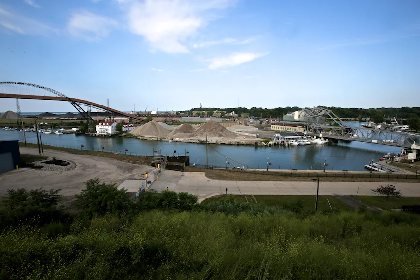
Fairport Harbor
A few miles north of Painesville, “past salt wells that constitute a basic resource for Lake County,” is Fairport Harbor. In 1940, primarily “Hungarians and Finns” lived here, working as fisherman or dockhands, shipping salt and iron ore out of the harbor. In 1959, Morton Salt purchased the salt deposits, drilling a 2,000 foot mine that was, according to the Morton website, the country’s “deepest and most modern salt mine.” Today it extends over three miles under Lake Erie. The company also donated over four-hundred acres of land above the mine that constitutes the Headlands Dunes State Nature Preserve and Mentor Marsh State Nature Preserve. Apparently, seagulls would rather spend their time on the salt mounds than in either of the preserves.

Morton Salt Mounds, Fairport Harbor, 2012

Birds on Salt Mound", 2012
The original lighthouse for the harbor from which the salt is shipped was designed in 1825 by none other than Jonathan Goldsmith. It was replaced in 1871 by the Grand River Lighthouse which still stands on a hill looking over the harbor. From this hill, one is offered a fine view of the West Breakwater Lighthouse that replaced it in 1925, as well as a public amphitheater which looks directly into the back of the water-treatment plant. Today, the brick light keeper’s house is a local maritime museum while the tower remains open for tours. None of these lighthouses are mentioned in TOG.
Next to the Grand River Lighthouse, the Mormon Historical Sites Foundation has placed a small plaque on a boulder. Fairport Harbor has the closest lake access to Kirtland, home of a Mormon temple that was completed in 1836. According to the monument:
Fairport Harbor played a transition role during the 1830s for many Mormon migrants who believed that they were obeying divine instruction that counseled them to “Go To The Ohio.” Hundreds of converts passed through this harbor on their way to and from the town of Kirtland which lay just twenty miles southwest. Many Siants were guided by Fairport’s Beacon’s of Light which shote upon the waters of Lake Erie. For those incoming Saints, the Fairport Lighthouse signaled a new ray of hope and for those missionaries embarking from her banks, new paths to travel in the quest for more converts to mormonism.
Though Mormonism is not mention as part of Fairport Harbor’s heritage in TOG, the editors devoted an entire tour (1A) to Kirtland and its relationship to Mormonism. Unfortunately, that tour would have to wait for another day.


Mentor
Back on U.S. 20, the scenery rapidly changes from semi-rural to suburban sprawl as you make your way towards Cleveland. Strip malls replace stand-alone stores and intersections become much more frequent.
TOG suggests the James Garfield House in Mentor for the next stop. This “frame structure set on a spacious lawn” was the President’s last home before he moved into the White House. I must confess that I was not heart-broken that arrived too late to visit what is now the James A. Garfield National Historic Site. As I have mentioned on earlier tours, there is a guilty disappointment in realizing you are not the first one to recognize a location’s historical importance. Like the great band you liked before everyone else in high school, a site’s popularity makes it somehow less appealing.
More interesting is the story TOG relays concerning the demise of the Willoughby Medical College, which makes up the entirety of the entry on the city of Willoughby:
Willoughby Medical College grew rapidly after its establishment in 1834 and had nearly 200 students when, in 1843, a Mrs. Tarbell discovered that her recently buried husband was not where he should have been—in his grave. The onus of the blame for Mr. Tarbell’s unseemly disappearance fell on the school. Virtually the whole town rudely invaded the college building, turned the rooms upside down searching for Tarbell’s vagrant remains, bashed in furniture, and tossed fragments of cadavers throughout the windows. Evil days fell upon the college because of this episode, and in 1847 it closed its door.
There is nothing in that story that makes a lick of sense, particularly why the disappearance of a body would inspire townspeople to destroy furniture in its medical college. But it is precisely these sorts of stories that make TOG so interesting. Why was this story chosen? How did it make its way to the editors of TOG? This question is particularly relevant because the manuscript guide does not contain this story at all, but an even more improbable story of the sort involving the construction of an Indian past I described earlier.
The manuscript guide states that “according to tradition” the medical college sat on land that saw “a bloody battle between Indian tribes.” This was known because “human bones, supposed to be those of the warriors, have been found.” If that definitive evidence did not prove enough Indian heritage, the guide goes on to describe a great granite boulder on the west bank of the Chagrin River that served as a “council table of a friendly little tribe of Indians, the Shagrins.” Not only did the “peaceful nomadic” hunters meet at the rock to “solve their problems and their relations with other tribes amicably,” but it was “here that the first councils between the Indian and white man were held.” It is probably no coincidence that the only Chagrin Nation I could find reference to is made up of Native Sons and Daughters, a Euro-American organization previously part of the YMCA’s controversial (and unseemly) Indian Guides and Indian Princesses program.
The boulder, if it ever existed under the Mentor Avenue Bridge, is now gone. However, I did find one of the greatest pieces of graffiti I have ever seen (speaking of unseemly).

"Toys and Candy" 2012
Euclid
Even in 1940, Euclid was “one of the important Cleveland suburbs.” As such, it was made up primarily of subdivisions that did not warrant a mention in TOG. The one POI for the city is the National Shrine of Our Lady of Lourdes. Winding through the woods one can visit the 14 Stations of the Cross, a series of dramatic representations of Christ in his final hours (I think). I was not particularly interested in the stations but I did go down to look at the sculpture of Christ that I had seen minutes before from Euclid Ave. His orientation suggests he is blessing the cars that pass.

Lady of Lourdes, 2012
The last stop before I entered Cleveland was NELA Park. Begun in 1911 by the National Electric Lamp Association (NELA), this ninety-two acre campus is home to General Electric Lighting, a subdivision of GE. Largely constructed in Georgian Revival, NELA park was the first industrial park in the world. In 1975 it was added to the National Register of Historic Places.

NELA Park Reflection, 2012